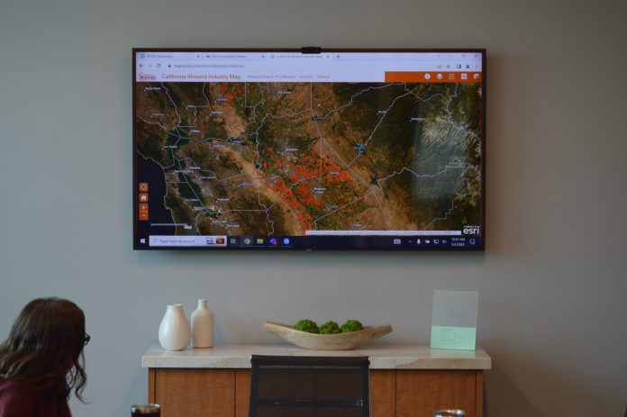
In 2011, based on production levels, growers on the Almond Board of California (ABC) suspected acreage reports from the USDA National Agricultural Statistics Service (NASS) were too low. They asked Land IQ for a second opinion.
“Growers on the Almond Board came to us and said, ‘We can’t achieve the average yields that the USDA-NASS are reporting, and we think we’re pretty good growers,’” said Joel Kimmelshue, principal scientist and owner of Land IQ. “So, can you map some almonds for us.”
That request launched acreage reporting for a company that today provides mapping for more than 50 crops in California, representing the entirety of the state’s irrigated crop footprint.
Launched in 2007 by Kimmelshue and Mica Heilmann, Land IQ hadn’t done acreage reporting when ABC requested it do so. But it was using spatial data from satellite imagery for other work in agriculture. Kimmelshue proposed that Land IQ start with Madera County.
“I said, ‘Okay, sure. Let’s cut our teeth on Madera County,’” he said. “And we did that, took them the map, they went out and checked our work and said, ‘Okay, you did pretty well. But we think you might have got lucky, so do it again.’ And we did it another year, and they said, ‘Okay, fine, now do the whole state.’”
On behalf of ABC, California Walnut Board, California Prune Board and the California Pistachio Research Board, Land IQ applied for and received a specialty crop block grant from CDFA, divvied up the cost according to acres and got to work.
“We did that a couple of years in a row. And then SGMA (the Sustainable Groundwater Management Act) hit and required the California Department of Water Resources to provide agricultural land use data set for the entire state of California, and we have been contracted with them ever since,” Kimmelshue said.
Today, Land IQ, which started in sublet offices with just five employees, has 40 employees between its Sacramento and Los Angeles offices. “And we’ve grown organically,” Kimmelshue said. “We haven’t had any growth targets. We just grow in response to the need for the work, and we focus on delivering very accurate results centered on heavy ground truthing for calibration and validation.”
It was that need, incidentally, that initially prompted Kimmelshue and Heilmann to launch the company. At the time, in the mid-aughts, the co-owners were working for a large international consulting engineering firm.
“Normally, a big engineering job would come in the door and there would be a smaller ag component to that,” Kimmelshue said. “And we would touch base with irrigation districts and commodity groups a lot, and there was just a need we felt for detailed mapping, detailed water use and crop estimates. So we decided, ‘Let’s go take a stab at this ourselves.’”
Growth Drivers
Early on, Kimmelshue and Heilmann hitched their wagon to accuracy, Kimmelshue said, and today, between satellite data and ground truthing, Land IQ boasts a crop mapping accuracy rate of over 97%.
“Their expertise is second to none,” said Richard Waycott, president and CEO of ABC, which contracts with Land IQ to provide almond acreage data twice a year. “We have really benefited from the work they do.”
In developing its reports, Land IQ accesses spatial imagery from four satellite services, including three government services and a paid subscription service, and validates the data with ground truthing.
“We can create a digital fingerprint of almonds, which is different than a digital fingerprint of walnuts, which is different than a digital fingerprint of alfalfa, because when you look at it from the sky, the texture, color and temporal differences are different from one crop to another,” Kimmelshue said. “Then all the pieces are put together and you create a fingerprint by crop type.”
The ground truthing not only calibrates the remotely sensed models, but also confirms, or validates, the company is properly identifying the crop type from the multiple components provided by the spatial data from satellites.
“We drive about 17,000 miles of ground truthing each year,” Kimmelshue said. Ground truthing typically involves three people riding in a car documenting thousands of fields by crop type and dropping points on an iPad. “We capture about 80,000 to 90,000 individual fields, or data points, a year.”
Expanded Portfolio
In addition to providing information on crop type, Land IQ can provide the age of an orchard and some climatic factors that may influence yields in an orchard. It can provide information on plant stress and on evapotranspiration (ET), which it does for approximately 40 Groundwater Sustainability Agencies each month. The ET data is used to determine groundwater pumping allocations in some cases or fee rates.
The expanded portfolio also has played a significant role in company growth, Kimmelshue said. “And there has been some luck involved,” he added.
Still, he said, none of this growth happens if the company doesn’t provide accurate results. And from its first acreage report, Land IQ has stood out for its accuracy, according to Waycott.
“The team that Joel and Mica have built there is top notch,” Waycott said. “And the data they provide is real-time data. And it is exact. So, that is something that has been very useful to us. And it has also been useful for USDA. We intentionally share the Land IQ data with USDA so they can take that data into consideration as they are going about their more traditional methodology of assessing acreage. And so, we are coming out with a better product at the end of the day.”
One other key Kimmelshue identified as instrumental to Land IQ’s expanding portfolio has been its vision. “The thing that we’ve been able to do is to be visionary,” Kimmelshue said, “to pay attention to what’s going on in the agriculture industry and see what the need is, and then moving quickly to address that need.”
Looking Back
Kimmelshue said he rarely takes the time to reflect on the success of the company he co-founded. When he does, he feels fortunate.
“I feel very blessed that I get to come and do the work that I do,” he said. “I can honestly say I’m happy to go work. I love my job.
“And I tell people that we’re doing stuff that is important,” he said. “And it’s never been done the way we do it, with accuracies that have never been achieved. And the most gratifying part is that the data we produce are being used in a hopefully objective, scientific manner to make tough decisions. ‘How much water can I pump?’ That’s a tough decision to make. But to have confidence in the data that we deliver helps people make smarter decisions.”
Oh, and that acreage report that the Almond Board asked for in 2011? It showed USDA-NASS figures were about 10% below actual acreage, which, when considering production figures, was about what ABC members thought was the case.


